Here you will learn:
- Groundwater classification
- Where does groundwater accumulate?
- The influence of burial depth on water quality
- Effective ways to find water
- Finding water from plants
- How to find water with your own hands
We find out how to find water for a well on the site. There are folk ways to find water - using clay pots, silica gel, bricks, observing nature and animals. As well as engineering methods of seismic exploration, electrical sounding and exploration drilling.
Groundwater classification
Before you start searching for water for a well, you should record the presence of such underground resources and determine the depth of the aquifer in the selected area.
Depending on the location and depth of occurrence, groundwater is divided into three types:
- Verkhovodka – lies within 2-5 meters from the surface. It is formed as a result of the filtration of atmospheric precipitation. Due to its shallow occurrence, this type of water can fluctuate: it sometimes rises after precipitation, then decreases during the dry period.
- Groundwater is aquifers in sedimentary rocks located approximately 8-40 meters from the surface. They are protected from above by several layers of rock, so they do not depend on the changing seasons. Sometimes, in depressions of the relief, they independently make their way into springs that supply tasty, clean water.
- Artesian waters most often lie at a depth of over 40 meters. They are distributed along cracks in rocky limestone. The water is characterized by the presence of mineral salts and the absence of clay suspension. The flow rate of artesian wells is quite stable.
The qualitative and quantitative parameters of the aquifer are of key importance.
The thickness of the earth is formed from rocks, some of which prevent the penetration of moisture - aquifers, while others, on the contrary, form aquifers
When searching for water to develop a well, you can use different methods, both using improvised means and using modern technology. But most often, hydrogeologists use the preliminary exploration method to search for an aquifer and determine its depth.
To get to a source that will provide high-quality and clean water, you will need to penetrate to a decent depth
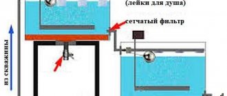
Pressure and non-pressure water
The water that you can obtain on the site is divided into pressure and non-pressure.
- Pressure or artesian water is located at great depths under pressure. This happens because the water-bearing layer is located between two impermeable layers under high pressure. Therefore, often when drilling a well, water can rise and flow like a fountain above the ground.
- Free-flow water, in turn, is not deep from the surface of the earth, so the pressure there is not high. Very often, deposits of such water can appear on the surface of the earth, which contributes to the appearance of springs.
If pressure water is almost always artesian water, then non-pressure water is divided into the following types:
- infiltration This water can only be found if there is a body of water nearby. It seeps into the soil layer from there;
- ground. This type of water is formed by melting snow and precipitation. As mentioned above, although this type of water is easily accessible, it still has a number of significant disadvantages.
Where does groundwater accumulate?
Before you start looking, it's worth learning a little more about groundwater. Moisture underground accumulates inside the so-called aquifers as a result of filtration of atmospheric precipitation. Liquid, sandwiched between waterproof soil layers consisting of stone or clay, forms reservoirs of various sizes.
Their location is not strictly horizontal; they can bend, forming in such areas peculiar lenses filled with water. Their volumes are also very diverse: from several cubic meters to tens of cubic kilometers.
A diagram of the occurrence of groundwater is necessary to have at least some idea of where the source may be
Closest to the surface, at a depth of only 2-5 m, lies the “overwater”. These are small bodies of water fed by precipitation and melt water. In dry times, they usually dry out and cannot be a source of water supply. In addition, water from them can most often be used only for technical purposes.
Of greatest interest to humans are deep aquifers containing large reserves of perfectly filtered water. They usually lie at a depth of 8-10 meters and below. The most valuable water, enriched with minerals and salts, is located even deeper, at a distance of about 30-50 m. Getting to it is possible, but difficult.
Location of aquifers in the ground
Water is retained in the ground thanks to water-resistant layers that prevent it from flowing either to the surface or deeper. The main component of the layers is clay, which is very resistant to moisture. Sometimes there are also stones. Between the clay layers there is a sand layer that retains clean water. This is the aquifer that must be reached in the process of digging a well.
Clay layers reliably hold aquifers
In some places the sand vein can be thin, in others it can be huge. The largest volumes of water are obtained in places where the waterproof layer breaks, which is not located strictly horizontally, but with height differences and bends. And where the clay makes a curvature, changes the direction of height, peculiar breaks are obtained that are filled with wet sand. These places are so saturated with water that they are called “underground lakes.”
The influence of burial depth on water quality
If you dig a well in the exact place where the water is located, the aquifer can be found even just two or two and a half meters from the earth’s surface. Knowledgeable people call this water layer perchal water and do not use it for drinking.
Proximity to the surface is not a good sign, because water has accumulated due to melting snow, infiltration of rain streams and water from nearby reservoirs. The quality of the water in it leaves much to be desired, because there is a high probability of sewerage and other dirt seeping through.
The deeper the aquifer is located, the less likely it is that all kinds of dirt located on the surface of the soil can spoil the water
In addition, the surface of such water is usually unstable. A well with perched water can completely dry up during the summer heat and fill up during the season of melting snow or prolonged autumn rains.
This means that water supply sources fed by perched water will also be empty, and summer residents will be left without water in the hot summer, when it is especially needed. Under such circumstances, it is better to forget about plans for the harvest. After all, no water is expected in the well until late autumn.
Therefore, we will look for deeper water. Experts believe that high-quality water is not so deep, only 15 meters from the soil level. In the sands, where the water is clean and tasty. The sand layer in which water is “stored” is a natural filter. By passing moisture through itself, it cleanses it of residual dirt and harmful elements.
If you are interested in installing a personal water source at your summer cottage, it is worth comparing the arguments in favor of installing a well or well, and also learn about their disadvantages. We invite you to read the comparative review.
Traditional methods
Even in ancient times, people learned to determine where a water source might be by observing nature and using basic physical patterns. The following folk methods can be noted:
- Observing the formation of fog. In a fairly warm season, in the morning and evening, a foggy cloud forms in places where groundwater is closest. The density of such a cloud indicates the depth of the aquifer. We must constantly observe such phenomena in our summer cottage and try to draw up an approximate map.
- Animal observation. Some animals are able to tell a person where to look for water. You just need to carefully observe their behavior. Thus, field mice will never dig holes if groundwater is close to them. Horses and dogs can be good helpers. In extreme heat, horses begin to beat their hoofs, and dogs begin to dig the ground in the places closest to the source. Poultry is also able to sense the proximity of water: chickens will not lay eggs in an area where the reservoir is close, and geese, on the contrary, try to nest closer to a water source.
- Observation of plants. Photo 2 shows some plant "indicators". Moisture-loving vegetation does not grow where the ground is too dry due to the deep location of the aquifer. In those areas where coltsfoot, hemlock, sorrel, and nettle are lushly green, you can plan a place for a well. In principle, even the approximate depth to the water carrier can be determined by plants. Willow, alder, and birch indicate shallow depth, and the slope of their crown indicates the location of the desired location. Cherry and apple trees do not like dampness, and therefore prefer areas with a buried layer. When groundwater approaches the surface, its root system begins to rot (see photo 2. Illustration of plant observation).
Effective ways to find water
There are more than a dozen ways to determine the proximity of water to the surface. Searching for water under a well can be done using one of the effective methods below.
Barometric method
A barometer reading of 0.1 mmHg corresponds to a difference in pressure height of 1 meter. To work with the device, you must first measure its pressure readings on the shore of a nearby body of water, and then, together with the device, move to the place where the source of water production is supposed to be arranged. At the well drilling site, air pressure measurements are taken again, and the water depth is calculated.
The presence and depth of groundwater can also be successfully determined using a conventional aneroid barometer
For example: the barometer reading on the river bank is 545.5 mm, and on the site - 545.1 mm. The groundwater level is calculated according to the principle: 545.5-545.1 = 0.4 mm, i.e. the well depth will be at least 4 meters.
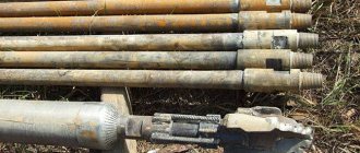
Exploration drilling
Test exploratory drilling is one of the most reliable ways to find water for a well.
Exploration drilling allows not only to indicate the presence and level of water occurrence, but also to determine the characteristics of the soil layers lying before and after the aquifer
Drilling is done using a conventional garden hand drill. Since the average depth of an exploration well is 6-10 meters, it is necessary to provide for the possibility of increasing the length of its handle. To carry out the work, it is enough to use a drill whose auger diameter is 30 cm. As the drill deepens, in order not to break the tool, soil excavation must be carried out every 10-15 cm of the soil layer. Wet silver sand can be observed already at a depth of about 2-3 meters.
The site for constructing a well should be located no closer than 25-30 meters relative to drainage trenches, compost and garbage heaps, as well as other sources of pollution. The most successful placement of a well is on an elevated area.
Aquifers that follow the terrain at higher elevations provide a source of cleaner, filtered water.
Rain perch and melt water always flows from a hill to a lowland, where it gradually drains into an impermeable layer, which in turn displaces clean filtered water to the level of the aquifer.
Seismic survey method
The search method is based on “tapping” the earth’s crust with an energy device through the action of sound waves and capturing response vibrations using a seismic-sensitive device.
Depending on the structure and material of the layers of the earth's crust, waves pass through them in different ways, returning as damped reflected signals, the properties and strength of which are used to judge the rocks representing these layers, the voids and the presence of aquifers, and the accumulation of water between durable aquifer layers. They take into account not only the strength of the returned vibration, but also the time it takes for the wave to return.
Water and rock do not reflect sound waves equally, therefore, knowing the difference in these indicators, one can judge where and how deep the aquifers are located.
Testing is carried out at several points on the site, all indicators are entered into a computer and processed by a special program to determine the location of the presence of the water carrier.
Compare the obtained data collected in places with similar geology, immediately adjacent to bodies of water, with data collected at the proposed drilling site. Or they find out the standard of the seismic signal, which is characteristic of most points in a particular location, and by deviation from this standard they identify the proposed area of occurrence of the aquifer. Artesian waters produce a high seismic background, several times higher than the standard one.
Electrical sensing method
The method allows using instruments to record the presence of water based on the resistivity of the earth layers. Special probing equipment is used.
Used to search for water at depths from ten to hundreds of meters.
Four electrode pipes up to one and a half meters long are driven into the soil. Two of them create an electrical voltage field, and the other two act as testing devices.
They are sequentially moved apart. At the same time, data are recorded from which resistivity is measured, potential differences are determined, thus consistently identifying indicators at different levels of the earth's crust.
Resistance varies depending on how high the moisture level is and what the composition of the rock layers is. This is an electrical sounding technique that helps determine the presence and depth of water.
Thus, electrical prospecting reveals information that is inaccessible to the seismic spectral method, being a less expensive search method.
The disadvantage of the method is that if the search area is enriched in fossil metals or is located close to railroad tracks, then sounding will become impossible.
Methods for determining a location for a well
Let’s make a reservation right away: we are listing popular, highly publicized methods of finding water - ancient, great-grandfather, prehistoric and almost antediluvian. The methods are sung in chorus. We won’t indulge in praise, we’ll just tell you how to find a place for a well according to folklore legends, although we are very skeptical about these methods.
The method for choosing a location for a well is based on the truth - water evaporates. We look in the morning - where the fog swirls, there the water is buried. If the fog is stubborn and rises in a column, this is good: a lot of water is buried. It is better to observe fogs in depressions. If your site is on a hill, fogs are not typical for it in principle. Is there no water or, contrary to the truth, does it not evaporate? It’s just that the fogs won’t show it - there’s nowhere for them to gather.
There’s a quick buzz word here: dowsing. The method requires the use of hands: you need to make two frames from aluminum wire - bend 40-centimeter (approximately) wires at a right angle (bend about a quarter) and insert them into the handles. The handles also need to be made - preferably from elderberry, willow, and viburnum. The method requires pressing your hands: elbows to your sides. A frame in each fist, and forward - we go, keep our hands parallel to Mother Earth, hold the wires also parallel. We transform into Edward Scissorhands, but not completely (we don’t cut the bushes, just a wire - an extension of the hands). Let's go and wait for it to bite. First we walk from the north (a compass helps - we mark the cardinal directions in advance) to the south, then we walk from east to west. Where the frames go crazy, there will be water. We walk the entire section lengthwise and crosswise: we determine the direction of the watercourse, we don’t rely on memory - we drive in pegs.
An excellent way: presumably, the presence of plants as such already indicates the presence of groundwater. Plants feed on water. Their root systems are different. Based on the growth of certain species and the condition of some trees, one can conclude about the availability of a resource and choose a location for a well. Birch, spruce, alder, and pine are moisture-loving and grow where the land is rich in groundwater. We were unable to imagine a building site covered in trees. Truly happy owners of houses located on forest lands are almost isolated cases. Therefore, let’s turn to more cunning representatives of the plant world, quickly developing and easily penetrating behind concrete fences and through asphalt.
Pistil-stamens “show” water located at a particular depth:
- reed - 1–3 m;
- sucker - 1–3;
- alfalfa - 1.4–2 m;
- wormwood - 3–5 m;
- licorice - 1.5–5 m;
- reed - up to 1.5 m;
- poplar - 0.5–3 m;
- cattail - up to 1 m;
- chiy - 1.5–5 m.
And here we come close to the reason for the fiasco of many do-it-yourself well diggers - they show plants, but they only show nearby water (like other methods, but it’s immediately clear which plant on the list is the key one). Digging a 1.5-2 meter well is the same as putting a rain barrel - the result is the same: there may or may not be water (as heaven decides), but you cannot drink it.
It is believed that animals help find a place for a well: they dig holes above the water (especially on hot days) and lay down in them. You can also put eggs under a frying pan: under whatever frying pan there is a steamy egg in the morning, there will be water. But this is all from the same opera.
Finding water from plants
The method of using indicator plants is used not only in the search for groundwater. Each plant is adapted to specific environmental conditions, so it grows only where it has the opportunity.
Height and root system
The taller the plant, the more water it requires. Therefore, tall plants are an indicator of the presence of underground water. Plants with a tap root penetrate far into the soil, sometimes far beyond the soil layer. Many large plants with taproots per unit area is a good sign.
Most likely, here you need to look for water at a depth of about 10 meters.
The concept of “large plant” in this case is relative. Of course, tall trees with tap roots in any case indicate the presence of water. However, you also need to pay attention to tall grass. If it has large, wide leaves, this is a good sign.
Species affiliation
All plants are divided into categories in relation to moisture. For our purposes, we need only two - drought-resistant and moisture-loving.
In trees, a sign of their requirement for moisture levels is the size of the leaf blade - the larger the leaf, the more water is needed to maintain it. However, not everything is so simple - trees living on waterlogged soils usually have thin leaves. This is necessary in order to evaporate as little water as possible in conditions where the water around is cold.
A striking example is willows, which grow near water but have narrow leaves.
Plant groups
If you see several willow or alder trees on the site, it means the groundwater is coming close to the surface. A good signal is the presence of large poplars (they need a lot of water), some types of maples, and elms.
But birch and oak groves are not very applicable as water indicators.
The fact is that they can grow well due to the accumulated layer of soil or dead organic matter in the form of litter, or they can take water from the ground horizons. Oak thrives in dry conditions, but can grow in almost swamps.
It is better to pay attention to the combination of trees and grass. For example, willow trees overgrown with sedge in the lower tier indicate that water is nearby. A good sign is an abundance of grass with leaves that are tender to the touch.
Observation when searching
The ability to take note of everything and analyze the information collected has never been superfluous. It was in this way that our ancestors, who were not yet armed with the achievements of science and technology, found water. What facts and natural phenomena will help us in our search for water?
Observation #1 - summer fogs
Fogs may appear in the area during the warm season. This natural phenomenon happens either in the early morning or late in the evening. If you observe fog in your area, pay attention to its density: it will be highest in the place where the water is closest to the soil surface.
If early in the morning you see fog in your garden, swirling or concentrated in one of its corners, then you can say with confidence that there is water in your area
The cause of such fog is the evaporation of water that is located underground. It will not stay in one place like ordinary fog. Moisture vapor may swirl or travel very low to the ground.
Observation #2 - animal behavior
Unlike people, animals know exactly where underground water is. It's a shame they can't tell us about it. Yes, they won’t be able to tell you, but please share your knowledge.
By observing the behavior of domestic and wild animals and birds, we can obtain all the necessary information:
- Dog. A dog is a man’s friend and will definitely help him in finding water for a well. In the heat, dogs are always looking for an opportunity to cool their body, so they dig holes where it is cooler. These are exactly the places we are looking for.
- Horse . When thirsty, a horse hits its hoof in a place where there is water underground.
- Harvest mouse. But mice love where it is dry. They will never make their nests near places of high humidity. It’s better to climb a tree or some building that rises above the ground level.
- Domestic bird. Chickens do not lay eggs where it is wet, but geese, on the contrary, choose places where underground aquifers intersect for their nests.
Even midges feel the proximity of water. If we look at its behavior at dusk, when the summer heat has already subsided, we will see columns of insects circling in the air precisely over those places where it is coolest - where there is what we need underground.
Dogs, like people, have difficulty withstanding heat and drought. They try to get to the coolest layers of soil, which are located just above the aquifer.
In a place unwittingly indicated to us by representatives of the animal world, we can safely dig an Abyssinian well to obtain water for watering the garden and for maintaining the territory.
Observation #3 - types of growing plants
Who would know about the presence or absence of water on the site, if not the plants? It is not surprising that they are used as indicators. If blackberries, buckthorn, lingonberries, bearberry, bird cherry, wood lice and wild rosemary are doing well on your site, then it makes sense to look for an aquifer - it is definitely present.
Plants do not always like excess water. If there is too much of it, they may even get sick and stop bearing fruit.
Take a closer look at the birch: its modest growth and gnarled trunk with curvatures indicate the presence of a nearby watercourse. Coniferous trees also prefer to grow where it is dry.
By the way, the presence of nearby groundwater is not always a benefit for gardeners. After all, cherries and apples prefer moderate humidity: their waterlogging can provoke tree diseases and fruit rotting.
Observation #4 - help from friends and neighbors
If your property is part of a gardening society or you have neighbors nearby, be sure to talk to them. As a rule, they have already solved the problems that you are struggling with today. If there is an operating well or well on their site, then you will have water too.
It is worth asking your neighbors at what depth the water is in their source and whether the level is stable. In this way, it is easiest and simplest to collect information and plan work on constructing a well. For private owners, surveying the owners of adjacent plots is the only expedient way to obtain hydrogeological data.
You should always maintain friendly relations with your neighbors: they will be the first to come to your aid, and if something happens, they will protect your property from thieves
Try to find out not only the current state of the local water intake, but also fluctuations in water levels throughout the year, as well as the composition of the water. Agree that it is not very pleasant to find your site flooded with flood waters in the spring. Receive vital information in a timely manner.
How to find water with your own hands
How to find water for a well on your property with your own hands without spending a lot of money?
Very easy. The most famous and well-known method is the use of aluminum frames. They sense magnetic fluctuations in the area well.
And water has a significant effect on the magnetic background. In order to find water with the support of aluminum frames, you need to carry out similar actions.
Take 2 pieces of thick aluminum wire and drive them fifteen cm apart until the immediate corner is removed. Cut fragments from the viburnum trunk along the length of the handles and remove the core. Insert the wire into the tubes so that it can scroll freely. Holding these well-known devices in your outstretched arms, walk around the area. During the period of movement, the edges of the wire must be moved in different directions.
If water underground appears on the right or left, then these two boundaries will turn in the required direction. And if the water-bearing well is in front of you, the edges of the wire will close. In order to be convinced of your own find, walk over the found water several times, but moving along a different line of movement. If everything happens again, then it is allowed to dig a well in the current area.
Using silica gel
To do this, granules of the substance are first thoroughly dried in the sun or in the oven and placed in an unglazed clay pot. To determine the amount of moisture absorbed by the granules, the pot must be weighed before instillation. A pot of silica gel, wrapped in non-woven material or thick fabric, is buried in the ground to a depth of about a meter in a place on the site where it is planned to drill a well. After a day, the pot with its contents can be dug up and weighed again: the heavier it is, the more moisture it has absorbed, which in turn indicates the presence of an aquifer nearby.
The use of silica gel, which belongs to the category of substances that have the property of absorbing moisture and retaining it, will allow you to determine in just a couple of days the most suitable place for drilling a well or constructing a well.
In order to narrow down the location of the search for water for a well, you can use several of these clay containers at the same time. You can more accurately determine the optimal location for drilling by repeatedly burying a pot of silica gel.
Ordinary red clay brick and salt also have moisture-absorbing properties. Determination of the aquifer occurs according to a similar principle with preliminary and repeated weighing and calculation of the difference in indicators.
Technology for finding water using vines
Our ancestors understood this very well! For this purpose, they used an ordinary willow rod. There was also a similar activity - dowsing. Willow senses liquid and nature has endowed it with the ability to reach for water. It is not difficult to carry out such searches personally.
To do this, you should: mark a willow branch with 2 branches coming out of 1 trunk, and dry it at room temperature. Take the edges of the branches in your hands and spread them apart so that the angle between them is approximately one hundred and fifty degrees. The outcome of a single barrel must look a little upward, and the muscles of the arms must be strained. With this device you need to walk around the area.
Where there is a water-bearing well, the branch of the vine will fall down without much difficulty.
Ancient method with clay pots
This is also an extremely old and classic way of searching for water. To do this, in order to clearly establish the zones where water occurs, the villages used earthenware. Before this necessary task, the pot was perfectly dried in the sun. In the area of the planned well, the dried product was placed in an inverted form. If there was actually water deep under the soil, then the pot would become very sweaty inside.
Current owners also use this technology, however, in a slightly improved version. A certain amount of silica gel is poured into the pot. It is also dried before use. The pot with the filling is weighed and placed in the water search area. To increase the likelihood of a positive ending, several such pots are placed throughout the entire area. After time, the pots are weighed: where it is heaviest, that’s where it is necessary to dig a well or borehole. Instead of silica gel, it is allowed to use small pieces of typical brick.
Service Animals
Your pets will give you a hint on how to find water in a well site. Since time immemorial, peasants have noticed that in a place where dogs or horses begin to dig into mother earth, there is a high chance of finding water. Chickens do not lay eggs when the area is damp, and geese, like waterfowl, will rather build a nest over the site of the future well. Ants do not prefer “watery” areas. If in the evening you notice a column of midges or mosquitoes over a certain area, you can look for some water here.
Fog
In those places where there is a light smoke in the early morning in the summer, or rather, groundwater lies nearby. The thicker the fog, the higher the water underground. You only need to look at the fog that is standing in the area without moving.
Salt and brick
Let's look at how to find water in a country house using typical kitchen salt and building bricks. It is necessary to choose a hot period when the ground is completely dry. Pour pre-dried salt or crushed scarlet brick into an unpainted gray clay pot. We weigh the container together with its contents. We wrap the pot in gauze or agrofibre and immerse it in the soil to a depth of half a meter. A day later, we buy our own homemade apparatus and weigh it again. If the difference in weight is quite significant, then water is not far away.
Practical Search Techniques
When the observation stage is already over, and the neighbor said that he bought the plot already with a well, the time comes for a practical search for water layers using standard or non-standard methods.
Method #1 - using glass containers
Finding the right number of glass jars of the same size is not a problem for those who occasionally do home canning. If you don’t have cans, buy them; the summer resident will definitely need them sooner or later.
The contents of ordinary glass jars will eloquently tell you where exactly the aquifer may be located: look for the container with the highest concentration of condensate
Throughout the entire area, you need to dig glass jars of the same size, bottom up, to a depth of at least 5 cm. The duration of the experiment is a day. The next morning, before the sun rises, you can dig out and turn over the dishes.
We are interested in those jars that contain condensate. There is more of it in banks located above aquifers.
Method #2 - use of hygroscopic material
It is known that salt is hygroscopic, that is, it can absorb moisture even from the air. Red brick, crushed into powder, has the same properties. Silica gel is another material that is perfect for our purposes.
To conduct the experiment, we will need several clay pots that are not covered with glaze. Choose a day when there has been no rain for a long time and we hope that it won’t rain in the next 24 hours.
You need pots like these, not coated inside or outside with glaze, because they “breathe” well and are able to let water vapors in.
We pour the material into the pots and weigh the resulting “devices”. It is better to number the pots and write down the data obtained. We wrap each pot in non-woven material and bury it at a depth of half a meter in the ground in different places on the site.
A day later we dig up the bookmarks and re-weigh them. The heavier the pot and its contents become, the closer to the place where it was laid the aquifer is located.
Looking for water using technical means
Aneroid barometer
These are the types of appliances that belong to the household category. The prefix “aneroid” (ancient/Greek) means anhydrous. The presence of an underground horizon (the results will be approximate) is determined by comparing pressure measurement data at different points. The use of a barometer is possible only if there is a body of water near or on the site. Artificial (for example, a pond, well) or natural - there is no fundamental difference.
Measurement technique
The first is carried out at an open source, the second - at the point where drilling is proposed. It is generally accepted that 1 mm Hg. Art. corresponds to 13 m. Therefore, if the difference in the instrument readings is, for example, 0.8, then the water in the selected location lies approximately 13 m x 0.8 = 10.4 m below the level of the reservoir.
Dowsing method
A long-known and effective way to find water. There are quite a lot of varieties of devices and techniques. When searching on your own, it is better to use 2 bent wires - aluminum or copper (it is somewhat more difficult to work with a frame, a vine and some other “devices”). Their shape is clear from the figure:
One in each hand. In order for them to rotate freely, they are placed in tubes, which simultaneously serve as handles (holders). Even a hollow elderberry (alternatively, a cut of reed or the like) will do if it is on the site or next to it.